|
Quadricentennial Challenge
Catskills Live! Trails & Wilderness Association issues a challenge to all —
venture forth and seek all 15 Quadricentennial Challenge geocaches. Go to many great places
throughout Ulster County — visit the shores of the Hudson, feel the cool air in an historic
cement mine, enjoy our small parks, ride on our rail trails, summit two Catskill peaks, and savor
the breath-taking view from Gertrude's Nose in Minnewaska State Park Preserve. Bask in our county's
treasures with family and friends, exercise your body, and build lasting memories. Specially minted
commemorative Quadricentennial geocoins are being released from Challenge geocaches in celebration of
the 400th anniversary of the exploration of the Hudson by Henry Hudson. All
15 Challenge caches will be available this summer. Funding for the Challenge was provided by Ulster
County and the Hudson River Valley Greenway.
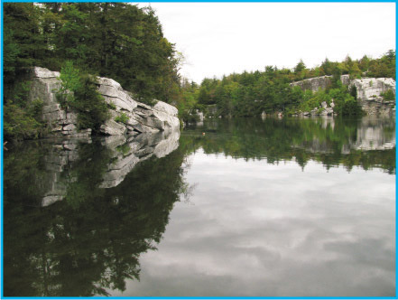
Minnewaska Lake
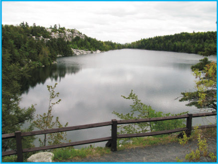 Minnewaska Lake is the third largest of the five crowning jewels of the northern Shawangunk Ridge.
The lake's crystal clear waters, seventy-eight feet at their deepest point, are bounded on the
northeast and northwest by sheer white, lichen-dappled, cliffs. Until about 1922, all five of the
Shawangunk sky lakes had abundant fish populations before acid precipitation lowered the pH of water
in four of the five ridge top lakes. Minnewaska Lake was known to have had perch, pickerel, trout,
and catfish. Abundant perch and pickerel from Minnewaska and Awosting lakes were once sold in
Ellenville fish markets. Today, the public enjoys 34-acre Minnewaska Lake for swimming and its many
carriage roads that boast numerous scenic vistas and bountiful blueberries.
Minnewaska Lake is the third largest of the five crowning jewels of the northern Shawangunk Ridge.
The lake's crystal clear waters, seventy-eight feet at their deepest point, are bounded on the
northeast and northwest by sheer white, lichen-dappled, cliffs. Until about 1922, all five of the
Shawangunk sky lakes had abundant fish populations before acid precipitation lowered the pH of water
in four of the five ridge top lakes. Minnewaska Lake was known to have had perch, pickerel, trout,
and catfish. Abundant perch and pickerel from Minnewaska and Awosting lakes were once sold in
Ellenville fish markets. Today, the public enjoys 34-acre Minnewaska Lake for swimming and its many
carriage roads that boast numerous scenic vistas and bountiful blueberries.
 In our intense focus on the recreational uses of Minnewaska Lake we often overlook its real
significance. Few people realize that during drought periods, Minnewaska Lake provides the only
continuous water source to both the Coxing Kill (south of the lake) and the Peters Kill (north of
the lake). It is their life blood. Whereas lake overflow at the southern end of the lake is
obvious during times of high lake levels, lake water also seeps through rocky talus debris and soil
here and at the northern lake shore at the beach area. Water that flows from the lake's southern
outlet soon sinks into fractures in the bedrock until it surfaces some 3,000 feet away in springs
that form the headwaters of Fountain Brook. Without this water, the down stream Coxing Kill could
not support its fish population. Water that flows through talus at the northern beach end of the
lake reappears far down the hillside in Bruin Springs that, in turn, form Bruin Stream that flows to
the Peters Kill. During dry periods, there is no water flow in the Peters Kill upstream of this
confluence — thus, at these times, the entire Peters Kill flow originates in Minnewaska Lake.
If the level of Minnewaska Lake were to be artificially lowered by more than a few feet during
drought periods, downstream recreational and water supply use of both the Peters Kill and Coxing Kill
would cease. Over 25 years ago, environmental groups worked hard to protect and preserve Minnewaska
Lake from overdevelopment, demonstrating that concerned and caring citizens can successfully protect
the environment.
In our intense focus on the recreational uses of Minnewaska Lake we often overlook its real
significance. Few people realize that during drought periods, Minnewaska Lake provides the only
continuous water source to both the Coxing Kill (south of the lake) and the Peters Kill (north of
the lake). It is their life blood. Whereas lake overflow at the southern end of the lake is
obvious during times of high lake levels, lake water also seeps through rocky talus debris and soil
here and at the northern lake shore at the beach area. Water that flows from the lake's southern
outlet soon sinks into fractures in the bedrock until it surfaces some 3,000 feet away in springs
that form the headwaters of Fountain Brook. Without this water, the down stream Coxing Kill could
not support its fish population. Water that flows through talus at the northern beach end of the
lake reappears far down the hillside in Bruin Springs that, in turn, form Bruin Stream that flows to
the Peters Kill. During dry periods, there is no water flow in the Peters Kill upstream of this
confluence — thus, at these times, the entire Peters Kill flow originates in Minnewaska Lake.
If the level of Minnewaska Lake were to be artificially lowered by more than a few feet during
drought periods, downstream recreational and water supply use of both the Peters Kill and Coxing Kill
would cease. Over 25 years ago, environmental groups worked hard to protect and preserve Minnewaska
Lake from overdevelopment, demonstrating that concerned and caring citizens can successfully protect
the environment.
 Archaeologic excavations in rock shelters in the Shawangunk Mountains have documented evidence of
Native American occupation dating back some 10,000 years. Similarly, excavations in the Wallkill and
Hudson valleys establish occupation before and at the time of Hudson's voyage up the river named for
him.
Archaeologic excavations in rock shelters in the Shawangunk Mountains have documented evidence of
Native American occupation dating back some 10,000 years. Similarly, excavations in the Wallkill and
Hudson valleys establish occupation before and at the time of Hudson's voyage up the river named for
him.
The Cache
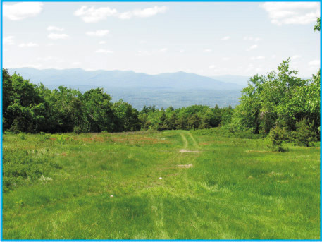
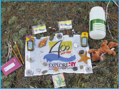 Access to the cache is largely via carriage roads near Minnewaska Lake. The cache is a 2-liter
cylindrical poly bottle hidden in an opening under a small boulder about 25 feet from the Castle
Point Carriageway. Nearby, there is a sweeping view of the Catskill Mountain escarpment. High
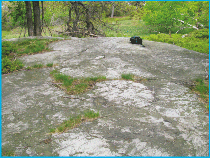
Point Mountain is the peak to your right. Bring a picnic to enjoy on the glacially striated
bedrock “table” next to this cache.
The cache is filled with kid-friendly items and, initially,
three NYS Quadricentennial Challenge geocoins designed to travel throughout the
Access to the cache is largely via carriage roads near Minnewaska Lake. The cache is a 2-liter
cylindrical poly bottle hidden in an opening under a small boulder about 25 feet from the Castle
Point Carriageway. Nearby, there is a sweeping view of the Catskill Mountain escarpment. High
Point Mountain is the peak to your right. Bring a picnic to enjoy on the glacially striated
bedrock “table” next to this cache.
The cache is filled with kid-friendly items and, initially,
three NYS Quadricentennial Challenge geocoins designed to travel throughout the
world.
This cache
was approved by the Park Service on
6-2-09 (Permit #: MSPP09-02).
Parking
 Minnewaska State Park Preserve is west of New Paltz, NY along Rt. 44/55. The 2008 NY-NJ Trail
Conference Map 105 (Shawangunk Trails - North) illustrates access routes well. Parking for this
cache is available at either the Minnewaska Lake parking area next to Minnewaska Lake or at the Lake
Awosting parking area. The upper lakeside parking area is much closer to the cache and avoids a
lengthy uphill trek. The park opens at 9 am and there is a $6 parking fee.
Minnewaska State Park Preserve is west of New Paltz, NY along Rt. 44/55. The 2008 NY-NJ Trail
Conference Map 105 (Shawangunk Trails - North) illustrates access routes well. Parking for this
cache is available at either the Minnewaska Lake parking area next to Minnewaska Lake or at the Lake
Awosting parking area. The upper lakeside parking area is much closer to the cache and avoids a
lengthy uphill trek. The park opens at 9 am and there is a $6 parking fee.
|