|
Quadricentennial Challenge
Catskills Live! Trails & Wilderness Association issues a challenge to all —
venture forth and seek all 15 Quadricentennial Challenge geocaches. Go to many great places
throughout Ulster County — visit the shores of the Hudson, feel the cool air in an historic
cement mine, enjoy our small parks, ride on our rail trails, summit two Catskill peaks, and savor
the breath-taking view from Gertrude's Nose in Minnewaska State Park Preserve. Bask in our county's
treasures with family and friends, exercise your body, and build lasting memories. Specially minted
commemorative Quadricentennial geocoins are being released from Challenge geocaches in celebration of
the 400th anniversary of the exploration of the Hudson by Henry Hudson. All
15 Challenge caches will be available this summer. Funding for the Challenge was provided by Ulster
County and the Hudson River Valley Greenway.
Gertrudes Nose — Isle in the Sky
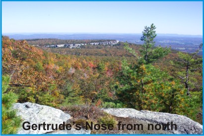 Gertrude's Nose may be the singular most spectacular hiking destination in Ulster County. Gertrude's Nose is located within the Minnewaska State Park Preserve in the Shawangunk Mountains. Its namesake, Gertrude Esselsteyn, was married around 1677 to Jacobus Bruyn. She was a woman of much ability and distinction who held large land grants in the Town of Shawangunk.
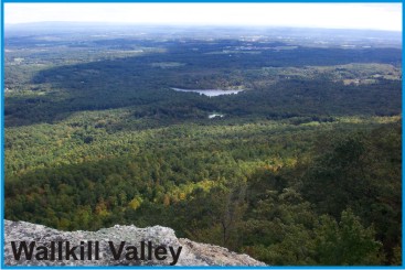
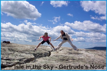 Gertrude's Nose is a prominent cliff escarpment that projects outward like a nose high above the Palmaghattkill Ravine to the north, northwest, and west and to the Wallkill Valley to the south. While not technically an island, this lofty piece of heaven is like an "isle in the sky."
Shawangunk
 Explorers following in the footsteps of Henry Hudson discovered the magnificent Shawangunk Mountains, eventually settling in the rugged mountains and making a living through farming, selling fish, quarrying the hard Shawangunk conglomerate for grindstones and building stones, and harvesting the bountiful blueberries.
 Today, much of the Shawangunk Ridge is preserved for hiking, biking, skiing, rock climbing, and other recreational activities. These activities compliment important habitat preservation and educational goals. Together, these factors provide important economic stimulus for regional businesses, including the nearby Mohonk Mountain House.
Gertrudes Nose's Trail
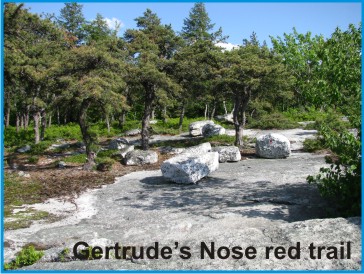
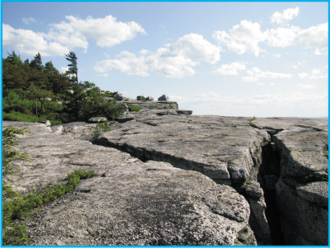
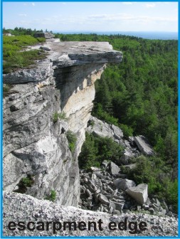 Much of the Gertrude's Nose Trail follows close to a rugged cliff edge, often with deep crevasses nearby. Care should be taken to keep children away from the cliff edge. Large expanses of glistening white bare bedrock ledge interspersed with clusters of dwarf pitch pines, mountain laurel, and blueberries offset sweeping panoramic views of the Palmaghatt Kill Valley, northwestern cliff lines, and the Wallkill Valley once Gertrude's Nose is reached. The majestic views along this trail are will make your heart sing.
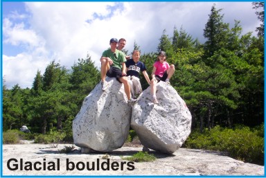
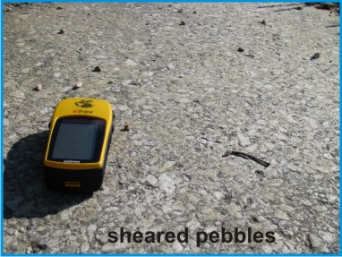 As you walk, stop and focus closer to your feet. Notice the smoothly polished white sandstone conglomerate, sometimes revealing sheared off, formerly rounded, pebbles. Look at the parallel grooves etched in the bedrock, left from rocks dragged along at the base of an ice sheet. Imagine the power of a mile-high ice sheet slowly grinding against the bedrock, overflowing and filling the nearby valleys, removing almost all the soil cover. Imagine ice frozen against steep cliffs, slowly ripping and plucking off huge blocks of bedrock. In time, the ice slowly melted away — leaving behind huge boulders at the base of the cliffs and some along the trail standing as sentinel soldiers greeting us from the past.
 These clues of bygone glaciers also tell the story of the deepening of the Hudson River channel. When ice sheets covered Gertrude's Nose, the ocean levels were much lower than today. Then, as the ice sheets melted, surging rivers deeply carved the Hudson channel. Without these ice sheets and glacial meltwaters, the Hudson River would not have been deep enough for Hudson to complete his 1609 voyage.
Stand near the tip of Gertrude's Nose and imagine for a moment that the bedrock escarpment nose is the bow of a special ship, sailing southwestward high atop a towering jagged ice sheet riddled with deep crevasses. As you sail back in time, steer southward far beyond the coastline of today until you eventually reach the ancestral outlet of the Hudson far out at sea.
The Cache
 Access to the cache is from Minnewaska Lake along red and yellow marked carriageways and then along a red marked footpath. The round trip hike is about 6 miles in length. Bicycles may be ridden on the carriageway portion of the access route. An easy few mile addition continuing east from Gertrude's Nose to the Millbrook Mountain scenic vista makes for a spectacular loop. The cache is a 2-liter cylindrical poly bottle hidden close to and southeast of the red trail (away from the cliff line).
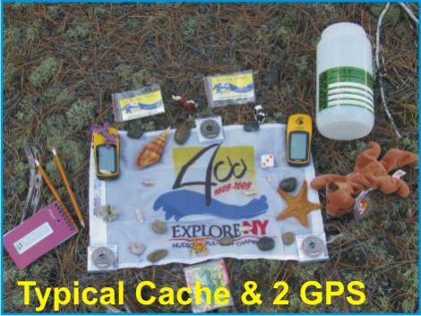
 The cache is hidden about 1,000 feet from Gertrude's Nose under a low overhang about 8 feet from the trail. For safety reasons, the cache was not placed near or in deep bedrock crevasses closer to the Nose itself. The cache is filled with kid-friendly items and, initially, three NYS Quadricentennial Challenge geocoins designed to travel throughout the world. This cache was approved by the Park Service on 6-2-09 (Permit #: MSPP09-01).
Parking
Minnewaska State Park Preserve is west of New Paltz, NY along Rt. 44/55. The 2008 NY-NJ Trail Conference Map 104 (Shawangunk Trails - South) illustrates access routes well. Parking for this cache is available at either the Minnewaska Lake parking area next to Minnewaska Lake or at the Lake Awosting parking area. The upper lakeside parking area is much closer to the cache and avoids a lengthy uphill trek. The park opens at 9 am and there is a $6 parking fee.
|